by Rosemary Tayler, 2019 Celestial Planting Calendar
Jet streams are narrow areas of very fast moving westerly (flowing from west to east) winds in the upper levels of Earth’s atmosphere. They can be thousands of kilometers long and over a hundred kilometers wide, but they are only a few kilometers deep. These upper atmosphere ribbons of wind have a tendency to push weather systems around the world. In the Northern Hemisphere, jet streams occur where a warmer air mass to the south meets a colder air mass to the north. In the Southern Hemisphere, it is the reverse—warmer air in the north meets colder air in the south.
These boundaries between air masses with significant differences in temperature are the pathways where the jet streams form. In the fall and winter, the jet stream in the Northern Hemisphere moves further south, allowing the colder air to reach more southerly latitudes. In the spring and summer, it retreats, allowing the heat from the tropics to move further north.
Jet streams are due to two influences: the heating of Earth’s atmosphere by the Sun and the rotation of Earth on its axis. When two air masses of different temperatures meet, a difference in air pressure results at this transition zone. But because of the Earth’s rotation, the wind does not flow immediately from hot to cold; instead the wind is deflected and flows along the boundary of the two air masses. Because the Earth rotates counterclockwise, the northern hemisphere winds move from west to east.
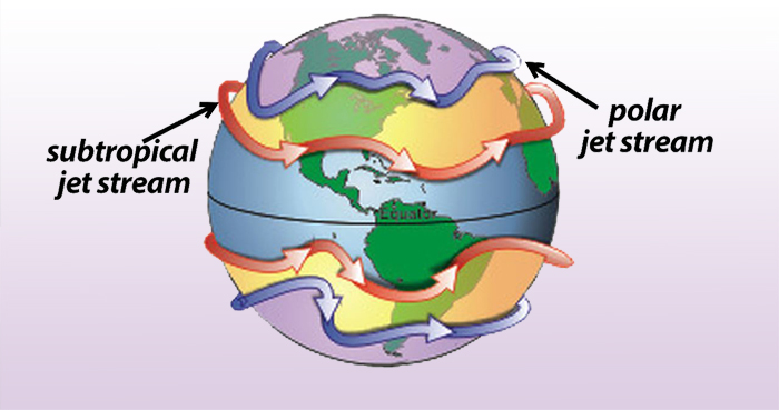
The strongest jet stream is the polar jet stream, which is 7 to 12 kilometers (4.3 to 7.5 miles) above the ground. The northern hemisphere polar jet flows over the middle to northern latitudes of North America, Europe and Asia and the oceans between these land masses. The sub-tropical jet stream occurs at a slightly higher altitude and it is weaker than the polar jet stream. Canada is often influenced by the polar jet stream. While the winds up there move at a speed of 100 to 160 kilometers per hour (km/h) (62 to 100 miles per hour), they can move as fast as 400 km/h (250 m/h) when there is a large temperature difference between the warm and cold air masses.
Land masses, particularly mountains, tend to slow down the flow of the jet stream. This slowing process creates a tendency for the air stream to move in a zigzig or meandering pattern. The meanders move more slowly than the rest of the air mass and this results an a slowing down of the weather systems at the Earth’s surface.
Low pressure systems are formed by rising warm air coming into close contact with large masses of adjacent cold air. During the fall and winter seasons, the sun moves lower in the sky and the land becomes cooler than adjacent bodies of water. As water retains its heat much longer than the land, areas such as those around Hudson’s Bay and the Great Lakes tend to develop low pressure systems. These low pressure systems are perpetuated by jet streams because they depend on a temperature gradient. As the temperature gradient decreases, the strength of the jet stream decreases and the growth of the low pressure system inhibited.
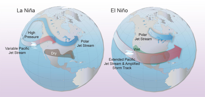
Both the polar and sub-tropical jet streams are also affected by temperature shifts in the Pacific Ocean known as El Niño and La Niña. During the wintertime of an El Niño phase, the jet stream along the Pacific Coast of North America moves farther south and brings more storms and colder weather to California and the southwestern American states, while the American interior becomes dryer and milder. In Canada, east of the Rocky Mountains, El Niño produces above average winter temperatures.
During La Niña cycles, the United States can experience dryer winter conditions, both along the west coast and in the southeastern states. In Canada, the jet stream retreats further north towards British Columbia in the winter, resulting in more precipitation in that province as well as in Ontario and Quebec, while the Prairie provinces may experience cooler than normal temperatures.
Next time you see the jet stream ribbon flowing across a weather map, remember to look for the colder and warmer regions of the atmosphere above and below that boundary.
For more information about La Niña and El Niño cycles, the reader is referred to the article on this topic in the 2017 Celestial Planting Calendar.
|